National Conservation Partnership Regions
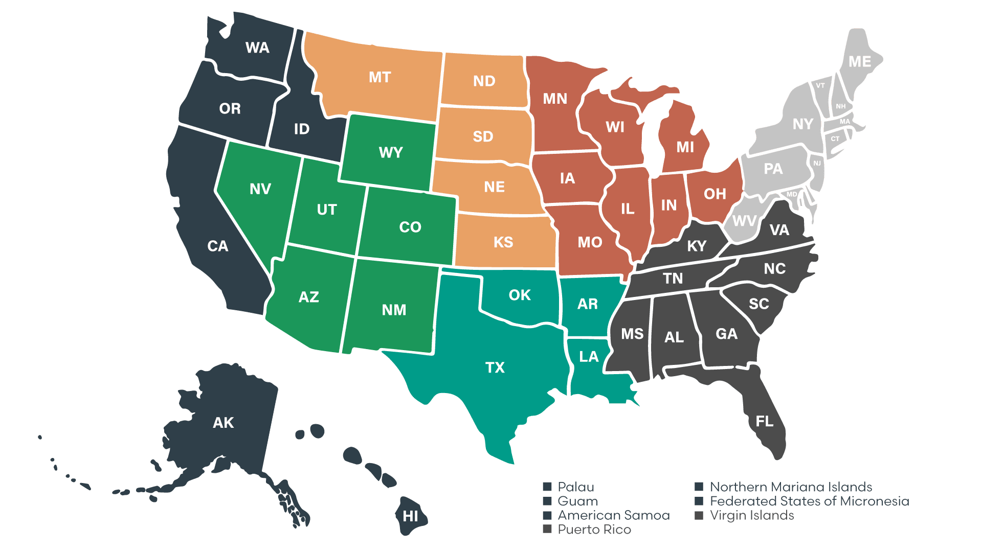
To strengthen coordination across the country, many federal and national conservation partners divide the United States into geographic regions. These regions help organize communication, training, and program delivery among states with similar resource concerns, landscapes, and conservation priorities. Each region has representatives who connect local district employees with national initiatives, share best practices, and provide professional development opportunities.
Four of the NCPP partners – NASCA, NACD, NCDEA and NARCDC – utilize the same regions, shown below in the interactive map. Click each region label to learn more.

States in region
New York, Pennsylvania, New Hampshire, Vermont, Maine, Massachusetts, Rhode Island, Delaware, New Jersey, Connecticut, West Virginia, Maryland, and the District of Columbia
Land types
Mountain ranges, lakes, rolling hills, crop land, cities
Region-specific practices
- Reduced tillage
- Cover crops
- Contour farming
- Silvopasturing livestock
- Select timber harvest
- Emergency stream intervention
States/Territories in region
Alabama, Florida, Georgia, Kentucky, Mississippi, North Carolina, Puerto Rico, South Carolina, Tennessee, Virginia, and the Virgin Islands
Land types
Rolling hills, river valleys, flat plateaus, forests, mountains, beaches, swamps, wetlands, islands
Region-specific practices
- Riparian buffer restoration
- Wetland enhancement
- Long-leaf pine conversion
- Erosion control on steep slopes
- Controlled burn planning
States in region
Iowa, Illinois, Indiana, Michigan, Minnesota, Missouri, Ohio, and Wisconsin
Land types
Forests, beaches, lakes, rivers, rolling hills
Region-specific practices
- Soil health
- Water quality and quantity
- Invasive species management
- Timber stand improvement
- Native species restoration
States in region
Arkansas, Louisiana, Oklahoma, and Texas
Land types
Gulf coast prairies, river delta alluvial soils, eastern woodlands, humid forests, karst terrain
Region-specific practices
- Drainage and water management
- Wetland restoration
- River levee setback/functional floodplain practices
- Bottomland hardwood afforestation
States in region
Montana, North Dakota, South Dakota, Nebraska and Kansas
Land types
Mountains, rolling prairies, lakes, rivers
Region-specific practices
- Native prairie restoration
- Rotational grazing
- Range reseeding
- Wind erosion control
- Shallow aquifer recharge
States in region
Arizona, Colorado, Nevada, New Mexico, Utah and Wyoming
Land types
Deserts, red rock, mountains, forests
Region-specific practices
- Irrigation-efficient systems
- Dry-land cover crops
- Hillside water harvesting
- Rangeland reseeding
- Fire-adapted forestry
States/Territories in region
Alaska, California, Hawaii, Idaho, Oregon, and Washington, Guam, Northern Mariana Islands, American Samoa, Palau, Federated States of Micronesia
Land types
Forests, mountains, beaches, rivers, lakes, islands, wetlands
Region-specific practices
- Forest health
- Fire planning and resiliency
- Invasive species management
Protection of native wildlife habitats and endangered species

Pacific
States/Territories in region
Alaska, California, Hawaii, Idaho, Oregon, and Washington, Guam, Northern Mariana Islands, American Samoa, Palau, Federated States of Micronesia
Land types
Forests, mountains, beaches, rivers, lakes, islands, wetlands
Region-specific practices
- Forest health
- Fire planning and resiliency
- Invasive species management
Protection of native wildlife habitats and endangered species
Northern Plains
States in region
Montana, North Dakota, South Dakota, Nebraska and Kansas
Land types
Mountains, rolling prairies, lakes, rivers
Region-specific practices
- Native prairie restoration
- Rotational grazing
- Range reseeding
- Wind erosion control
- Shallow aquifer recharge
North Central
States in region
Iowa, Illinois, Indiana, Michigan, Minnesota, Missouri, Ohio, and Wisconsin
Land types
Forests, beaches, lakes, rivers, rolling hills
Region-specific practices
- Soil health
- Water quality and quantity
- Invasive species management
- Timber stand improvement
- Native species restoration
Northeast
States in region
New York, Pennsylvania, New Hampshire, Vermont, Maine, Massachusetts, Rhode Island, Delaware, New Jersey, Connecticut, West Virginia, Maryland, and the District of Columbia
Land types
Mountain ranges, lakes, rolling hills, crop land, cities
Region-specific practices
- Reduced tillage
- Cover crops
- Contour farming
- Silvopasturing livestock
- Select timber harvest
- Emergency stream intervention
Southwest
States in region
Arizona, Colorado, Nevada, New Mexico, Utah and Wyoming
Land types
Deserts, red rock, mountains, forests
Region-specific practices
- Irrigation-efficient systems
- Dry-land cover crops
- Hillside water harvesting
- Rangeland reseeding
- Fire-adapted forestry
South Central
States in region
Arkansas, Louisiana, Oklahoma, and Texas
Land types
Gulf coast prairies, river delta alluvial soils, eastern woodlands, humid forests, karst terrain
Region-specific practices
- Drainage and water management
- Wetland restoration
- River levee setback/functional floodplain practices
- Bottomland hardwood afforestation
Southeast
States/Territories in region
Alabama, Florida, Georgia, Kentucky, Mississippi, North Carolina, Puerto Rico, South Carolina, Tennessee, Virginia, and the Virgin Islands
Land types
Rolling hills, river valleys, flat plateaus, forests, mountains, beaches, swamps, wetlands, islands
Region-specific practices
- Riparian buffer restoration
- Wetland enhancement
- Long-leaf pine conversion
- Erosion control on steep slopes
- Controlled burn planning
The fifth NCPP partner, NRCS, utilizes a different regional map, shown below.

– Hugh Hammond Bennett